Key Takeaways
- Understand the transformative impact of drones on agriculture, enhancing crop management and resource use.
- Learn the essential features to consider when selecting an agricultural drone for your farming needs.
- Discover the step-by-step process of planning and executing a successful drone flight for crop monitoring.
- Gain insights on the regulations and safety practices necessary for operating drones in agriculture.
- Explore the future possibilities and current innovations in drone technology that benefit sustainable farming.
The High-Tech Harvest: How Drones are Changing the Game
Imagine a farmer, standing in a vast field, with the power to see every inch of their crops without taking a step. This isn’t a scene from a futuristic movie—it’s happening right now with precision agricultural drone technology. Drones, or unmanned aerial vehicles (UAVs), are revolutionizing the way farmers monitor, manage, and maximize their yields. They’re not just flying cameras; they’re data-gathering workhorses that can significantly cut down on time and labor.
Here’s the scoop: drones can cover large areas quickly, capturing high-resolution images that reveal much more than the naked eye can see. They can detect plant health, monitor crop growth, and even spot pest infestations. Most importantly, they allow farmers to make informed decisions fast, leading to more efficient use of resources like water and fertilizers.
Maximizing Crop Yields with GPS and Data Analysis
At the heart of drone technology is the ability to navigate precisely using GPS and to analyze the collected data for actionable insights. It’s not just about taking pretty aerial pictures; it’s about understanding what those images tell us. With GPS, drones can be programmed to fly specific patterns over a field, ensuring complete coverage and data collection.
Once the data is in hand, it’s all about turning it into something useful. Specialized software can interpret the images to identify areas that need attention, whether it’s a section that requires more irrigation or a spot where pests are causing trouble. Therefore, farmers can target their interventions, saving time and money, and boosting yields.
Navigating the Skies: A Guide to Agricultural Drones
Choosing Your Agricultural Drone: Features to Look For
When you’re in the market for an agricultural drone, it can feel like there’s an overwhelming number of options. To simplify things, here are the key features you should focus on:
- Battery Life: Look for drones with a long flight time to cover more ground without needing a recharge.
- Camera Quality: High-resolution cameras are crucial for capturing the detailed images necessary for analysis.
- Stability and Reliability: Durable drones that can withstand various weather conditions are a must.
- Software Compatibility: Ensure the drone works with agricultural software platforms for data analysis.
- After-Sales Support: Good customer service can be a lifesaver if you encounter issues with your drone.
Remember, the best drone for you depends on the size of your farm, the type of crops you’re growing, and the specific challenges you face. Therefore, it’s worth taking the time to research and perhaps even speak with experts or other farmers who have experience with drones.
Flight Planning for Precision Farming: Step-by-Step Instructions
Getting your drone up in the air is more than just a matter of hitting the ‘take off’ button. Here’s a quick guide to help you plan your flight:
- Define Your Objectives: Know what you want to achieve with the drone flight—whether it’s checking for pests, disease, or assessing crop health.
- Check the Weather: Ideal conditions are crucial for a successful flight. Avoid windy or rainy days.
- Pre-flight Checklist: Ensure your drone’s batteries are charged, the camera is clean, and all components are functioning.
- Program Your Route: Use GPS to set waypoints and flight paths that cover the areas you need to monitor.
- Conduct a Test Flight: Before the actual survey, do a quick test to make sure everything is working as expected.
- Execute Your Flight: Fly the programmed route, making sure to monitor the drone’s performance and battery levels throughout.
- Analyze the Data: After the flight, download and analyze the data with the help of specialized software.
Remember, practice makes perfect. Don’t be discouraged if your first few flights don’t go as planned. With each flight, you’ll gain valuable experience that will help you get the most out of your drone technology.
Farm Mapping and Data Collection Basics
Now, let’s dig into the nitty-gritty of farm mapping and data collection with drones. This is where the magic happens, turning high-flying tech into down-to-earth benefits. Farm mapping is the process of creating detailed, accurate representations of your fields to analyze and optimize crop production. Drones make this task easier and more precise than ever before.
Example: A wheat farmer uses drone mapping to identify uneven growth patterns in the field. By analyzing the aerial data, they discover a section of the crop isn’t getting enough water due to a malfunctioning irrigation pivot. Quick action is taken to repair the equipment, ensuring the entire crop receives adequate water.
To start mapping your farm, you’ll first need to set clear goals. Are you looking to assess plant health, optimize irrigation, or perhaps monitor the effects of fertilizer application? Once your objectives are clear, it’s time to plan your drone’s flight path to cover all the necessary areas of your farm. After the flight, you’ll have a wealth of data that can be processed into actionable insights.
Collecting data is only part of the equation. The real value lies in turning this data into actionable insights. With the right software, you can transform the raw images and sensor readings into detailed maps that show variations in plant health, soil moisture, and more. These maps are invaluable for making informed decisions about where to focus your efforts, whether it’s applying nutrients, water, or protecting against pests and diseases.
It’s essential to fly regularly, capturing data throughout the growing season. This way, you can track changes and trends, adjusting your management practices in real time. The result? Healthier crops, better yields, and a more profitable farm.
Ensuring Safety in the Skies: Best Practices for Drone Operations
While drones offer a world of possibilities, they also come with responsibilities. Ensuring safety during drone operations is paramount. It starts with understanding the drone’s capabilities and limits, reading the manual thoroughly, and getting familiar with its features before taking to the skies.
Always conduct a pre-flight inspection. Check the drone’s battery levels, propellers, and camera equipment to ensure everything is in working order. Keep your drone within line of sight at all times and be mindful of weather conditions that can affect flight stability.
Moreover, be respectful of privacy and aware of your surroundings. Avoid flying over crowded areas or neighboring properties without permission. Safety isn’t just about the drone; it’s about protecting people, animals, and property on the ground.
- Read and understand the drone’s user manual.
- Perform pre-flight checks and ensure the drone is in good condition.
- Keep the drone within visual line of sight during operation.
- Be aware of and comply with local privacy laws.
- Monitor weather conditions and avoid flying in adverse weather.
Understanding Drone Regulations and Compliance
Before you start buzzing around your fields, it’s critical to know the rules of the sky. Drone regulations vary by country and sometimes even by region within a country. In general, you’ll need to register your drone with the appropriate aviation authority, and you may need to obtain a special license or permit if you’re using it for commercial purposes.
It’s not just about bureaucracy; these regulations are in place to keep everyone safe. For example, there are often restrictions on how close you can fly to airports and other restricted areas. Make sure you’re up to date with the latest regulations to avoid hefty fines and ensure safe and legal flights.
Mitigating Risks: Safety Features and Flight Protocols
Drone technology has advanced to include various safety features that help mitigate risks during flight. Look for drones equipped with obstacle avoidance systems, automatic return-to-home functions, and geofencing capabilities that prevent them from straying into restricted areas.
Developing standard flight protocols is also essential. These protocols should include steps for dealing with unexpected events, such as losing GPS signal or encountering wildlife. By preparing for these scenarios, you can reduce the risk of accidents and ensure your drone operations are both safe and efficient.
Optimizing Crop Management with Drone Analytics
Once you’ve safely collected your aerial data, the next step is to harness the power of drone analytics. This is where you’ll see a return on your investment. Advanced analytics software can interpret the collected data to provide insights into crop health, identify areas that need attention, and even predict future growth patterns.
For instance, Normalized Difference Vegetation Index (NDVI) maps can be generated from drone imagery. These maps use special algorithms to measure plant health based on how the plants reflect light at certain frequencies. Healthy plants reflect more infrared light than unhealthy ones, so these maps can be a powerful tool for spotting problems early on.
Interpreting Aerial Data for Improved Crop Health
Interpreting aerial data is about more than just spotting the problem areas. It’s about understanding the ‘why’ behind the issues. Is a particular patch of crops struggling because of a pest infestation, nutrient deficiency, or a lack of water? By combining drone data with ground truthing—where you verify the drone’s findings in the field—you can pinpoint the cause of the problem and take corrective action.
This proactive approach to crop management means you can address issues before they become big problems, ensuring your plants are healthy and your yields are high. It’s about working smarter, not harder, and letting technology take some of the guesswork out of farming.
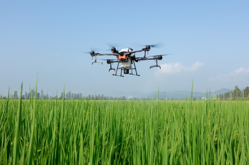
Precision Spraying and Targeted Irrigation Techniques
One of the most exciting applications of drone technology in agriculture is precision spraying and targeted irrigation. Drones equipped with spraying attachments can apply fertilizers, pesticides, or herbicides precisely where they’re needed, reducing waste and preventing runoff into the surrounding environment.
Similarly, drones can help optimize irrigation practices. By identifying areas of the field that are drier than others, you can adjust your irrigation system to deliver water more efficiently, ensuring every plant gets just the right amount. This not only saves water but also improves crop health and yield.
In conclusion, drones are not just changing the way we farm; they’re making it better. By embracing precision agricultural drone technology, you’re stepping into the next generation of farming—a world where efficiency, sustainability, and high yields go hand in hand. So, get ready to take your farm to new heights, literally and figuratively, with the power of drones.
The Future of Farming: Innovations in Agricultural Drones
As we peer into the future, it’s clear that drones will play an increasingly vital role in farming. Innovations in drone technology are rapidly advancing, bringing new capabilities that will further empower farmers. We’re looking at drones that can not only map and monitor but also autonomously make decisions on when to water, fertilize, or even harvest crops.
These advancements are not just about efficiency; they’re about creating a more sustainable form of agriculture. With drones, farmers can minimize their environmental footprint, reducing the overuse of water and chemicals. And that’s just the beginning. The integration of artificial intelligence and machine learning means drones will become even smarter, adapting to the unique needs of each farm.
Advancements on the Horizon: What Farmers Can Expect
In the near future, expect to see drones equipped with more sophisticated sensors, like multispectral or hyperspectral cameras, which can detect plant stress at an even earlier stage. Battery life will continue to improve, allowing for longer flights and larger area coverage. We might even see drone swarms, where multiple drones work together to cover vast tracts of land with incredible efficiency.
Another exciting development is the potential for drones to become part of an integrated farm management system, communicating with ground-based robots and satellite imagery to provide a comprehensive view of agricultural operations. This level of integration will lead to precision farming becoming the norm, not the exception.
How Drones are Contributing to Sustainable Agriculture
Drones are already contributing to sustainable agriculture by enabling farmers to use resources more wisely. By providing detailed data on crop health, soil conditions, and water usage, drones help farmers to:
- Reduce the overuse of water through targeted irrigation.
- Minimize chemical runoff with precision spraying.
- Lower emissions by optimizing field operations and reducing the need for heavy machinery.
These contributions are just the tip of the iceberg. As drone technology continues to evolve, its role in promoting sustainable farming practices will only grow stronger, helping to feed our planet while protecting its resources.
Frequently Asked Questions (FAQ)
What are the environmental benefits of using drones in farming?
The environmental benefits of using drones in agriculture are significant. They allow for precision farming, which leads to:
- Less chemical usage as pesticides and fertilizers are only applied where necessary.
- Reduced water consumption through targeted irrigation.
- Lower fuel emissions since drones can monitor fields more efficiently than traditional methods.
These practices not only benefit the environment but also help farmers save on costs and increase crop yields.
Can drones be used for both large-scale and small-scale farming?
Absolutely! Drones are incredibly versatile tools that can be scaled to suit any size operation. For large-scale farms, drones can quickly cover and monitor vast areas, making them indispensable for efficient crop management. On the other hand, small-scale farmers can benefit from the precision and data that drones provide, allowing them to compete with larger operations by increasing their crop quality and yield.
How often should I use drones to monitor my crops?
Monitoring frequency will depend on several factors, including the type of crops, the stage of growth, and the specific issues you’re facing. As a general rule, a weekly flight can provide good insights into crop health and progress. However, during critical periods, such as just before harvest or after a significant weather event, more frequent monitoring may be necessary.
What kind of training is required to operate agricultural drones?
Operating agricultural drones requires some training to ensure safety and compliance with regulations. Many countries require operators to have a drone pilot certification, which involves learning about airspace regulations, weather, drone mechanics, and safety practices. Additionally, it’s beneficial to have training in agricultural drone software to analyze the data collected during flights.
Are there any government incentives for using drones in agriculture?
Some governments offer incentives for adopting precision agriculture technologies, including drones. These incentives can come in the form of tax breaks, grants, or subsidies. They’re designed to encourage farmers to invest in technologies that increase efficiency and sustainability. It’s worth checking with local agricultural extension services or government agencies to see what incentives might be available in your area.